February 27, 2013

1955 - PCC Streetcar crossing bridge in Clayton

Location: N. Central bridge

Source:  David Bales Collection
1955


The camera angle is pointed east near Meramec Avenue. The bridge with the streetcar was located behind and to the north of Meramec School. The smaller bridge in the background crossed the valley from the southern end of Bemiston over to North Polo. The Hanley Bridge is out of sight in the far distance. The 1976 Clayton History book tells about the Bemiston bridge. Notice the Rock Island rail lines are gone. The little road on the left became Shaw Park Drive. I have no knowledge of the white building----maybe someone else remembers. - Dave Bales

December 12, 2010

1987 - The Trolley 04 in transit to museum

Location: Southbound N. Brentwood Boulevard next to Shaw Park.

Source:  David Bales Collection
1987

Pevely Fountain

Location: Forsyth Boulevard and Ritz Carlton Drive

Source: Clayton School District collection photocopy
unknown year

1925 - N. Meramec and Pershing

Location: Old Town Clayton Neighborhood; unknown child in photo

Source: The Human Family collection
1925

1948 - Straubs Grocery opens at new location on Forsyth in Clayton

Location: southwest corner of Forsyth and Maryland in Clayton, MO

Source: St. Louis Post Dispatch newsclip
1948

1937 - Rock Island Railroad tracks

Location: Looking east, north of the 7600 block of Carrswold. This location is now the Forest Park Expressway and the Ritz Carlton otel would be on the leftside.  Pictured are Ginny Degelow, Skippy, and Mansy Degelow.

Source: David Bales collection
1937

July 19, 2010

1904 - World's Fair Phillipine Exhibit - Igorot dwelling

Source: original picture owner unknown; image contributed by Don Senti

The Philippine Exposition spanned the area that is now the easternmost edge of the city of Clayton, from Skinker Road in the east to Big Bend Boulevard in the west, and from Clayton Road in the south to Millbrook Boulevard in the north. The Igorot Village was nearest the corner of Wydown Terrace and Skinker Road on the plot of land where Wydown Middle School sports teams now compete.

November 21, 2009

1930 Postcard - Country Club Court

Location: Looking west from N. Hanley. Most homes were built in the mid-1920's.

Source: Private Collector
1930 postcard

November 17, 2009

1909 Postcard - Trust Company of St. Louis County

Location: 52 S. Central Avenue at Carondelet (the N.E. corner). It was an ornate white concrete and stone building, built in 1906. It was sold and later occupied by the Guarantee Trust Company and the bulding was demolished.
Source: Private collector
1909 postcard

1930 Postcard - Clayton Presbyterian Church

Former Location: The N. E. corner of Hanley at Forsyth. According to Dickson Terry, this former building was built in 1913 and was used by the church until 1931 when the congregation merged with Central Presbyterian Church. The building next operated as the Bopp Funeral Home from 1931 until 1961. The building was demolished to make way for the Missouri Savings and Loan Building in the early 1960's. Currently the bank is called US Bank, located at 10 N. Hanley Road.
Source: Private collector
1930 postcard

1930 Postcard - Clayton Masonic Hall

Location: N. Meramec Avenue

Source: Private collector
1930 postcard

1930 Postcard - Clayton Methodist Church

Location: 101 N. Bemiston at Maryland Avenue (the N.W. corner)
Source: Private collector
1930 postcard

1930 Postcard - Polo Drive residences

Source: Private collector
1930 postcard

1978 - Cyranos's Restaurant

"Location: N.E. corner of Clayton Road and DeMun. Commerce Bank is presently located there."
--David Bales
Source: David Bales collection
1978
Cyrano's

November 16, 2009

1908 - Home located at 121 N. Hanley

Source: Private collector
1908

1949 and 1942 - Mobilgas Gas Station

Location: Clayton Road and Big Bend Boulevard

Source: Private collector
1949 - Southwest view of Clayton and Big Bend


Source: Newspaper clip from the collection of David Bales
1942 - Southwest view

October 25, 2009

1911 - Autenreith Hotel and Hotel Claymo

Location: N.E. corner of Forsyth at N. Meramec Avenue
January 2, 1911 Fire at Autenreith Hotel

January 2, 1911 Fire at Autenrieth Hotel


The Autenreith Hotel was rebuilt after the 1911 fire. The name changed to the Hotel Claymo in 1924 when the hotel was sold to Joseph Parks, according to Dickson Terry. It ceased to be a hotel in the late 1920's. It became an office building for General Title Company, and then the Bond Clothing Company occupied the space from 1950 to 1957. It was returned to office space for the Chicago Title Company.

Source: Private collector
Postcard - Date unknown


Source: Private Collector
1930 postcard

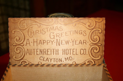
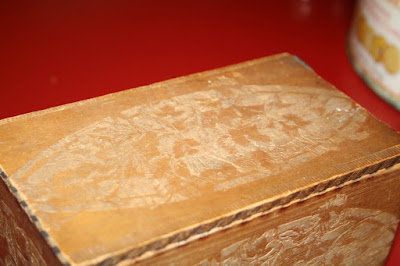
Autenreith Hotel Souvenir

"The imprint says "Christmas Greetings- A Happy New Year from Autenreith Hotel Co. Clayton, MO. The box is about 5" long and 3"tall and 3" wide with a hinged top and some intricate carvings on all exterior sides. My grandparents lived in St Louis until the early 1970's and this was some of the things they brought south with them."
--Chuck Davis
Source: From the photo collection of Chuck Davis
souvenir
souvenir
souvenir
souvenir

October 24, 2009

Al Baker's Restaurant

Location: Clayton Road and Brentwood. The fine dining restaurant was established in 1966 and closed in 1994. The restaurant building no longer exists. Linen N' Things was built on that location and it closed in 2009.
Source: Private collectorDate unknown

August 5, 2009

1953 and 1951 - Stevenson's Gas Station

"This view is to the WEST with Skinker Road shown in front, Clayton Avenue would be on the left and rear of the station and Clayton Road is on the right. This station was torn down in 1959-60 and a new service station was erected. Nowadays, the brand of gas is BP but the sign was such a landmark that special permission was obtained to keep the present Amoco sign. "
--- David Bales

Source: Newspaper clip from the collection of David Bales
1953
1953 gas station

gas station

Source: Private collector
1951 postcard

August 4, 2009

Esquire Bowling Lanes

Location: Clayton Road at Big Bend
Source: Private collector
Date unknown

1927 - N. Central Avenue

Source: Private collector
1927 - Looking north


Date unknown - S.E. corner of N. Central at Forsyth Avenue

1907, 1930 and 1951 - St. Louis County Court House

Source: Private collector
1907

Date unknown

1930 postcard


1951

The Taylor School

Location: N. Central and Kingsbury. The school and building no longer exists. The location is now Taylor Park.

Date unknown

Barford Chevrolet

Date unknown

Clayton High School

Date unknown

1940 - New Clayton Post Office Branch

Source: Private collector

1959 and 1957 and 1930 - St. Louis Institute of Music (former orphanage)

The Institute was founded in 1924 by J. P. Blake Sr. It was originally known as "The Progressive Series Teachers College". It was also known to be an orphanage home at one time. The address of the Institute was 7801 Bonhomme Avenue - Clayton 5, Missouri. This was at the intersection of Bonhomme and Bemiston. The building does not exist any longer.


Source: Private collector - 1957


Source: Private collector - 1930 postcard

April 30, 2009

1922 - Big Bend at Millbrook

Source: unknown
1922 - Looking north

1968 and 1951 - Aerial views of Clayton

"It's of paramount importance to credit this photo to Robert Srenco, although I purchased this and three other really fine shots from him for a goodly amount three years ago, they are in my collection now---all four. Something like this is just wonderful to study. For example, notice the old Forest Park Parkway is not yet constructed. Shaw Park Drive runs EAST to Bemiston, it appears to be blacktop, and a smaller road runs east to Hanley. The old railroad right-of-way, south of Shaw Park Drive is a parking lot from Meramec up to the NE corner of Meramec School. The court house area is a sunken parking lot, the old courthouse and jail is there along with the 1952 courthouse."
--- David Bales


Source: Robert Srenco Photo from the collection of David Bales
1968 - View from S.W. to N.E.

Source: Newspaper clip from David Bales collection
1951 - View from S.W. to N.E.

newspaper clipping